Source: The Hindu, The Indian Express
Relevance: GS I – Physical Geography
Why in News
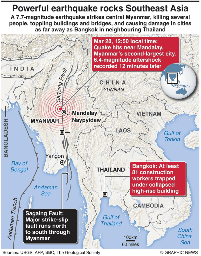
At least 1,600 people were killed as of Sunday by a strong 7.7-magnitude earthquake that rocked central Myanmar on Friday and caused at least six aftershocks. The earthquake destroyed buildings in Mandalay, the nation’s second-largest city.
Geotectonic Setting of Myanmar
Since the southern Sagaing fault is situated on a thicker pile of alluvium that was deposited by the Irrawaddy, which increases seismic energy, a review of the damage pattern shows that a large portion of the destruction was concentrated there rather than in the northern sections of the fault.
International Impact
Yunnan Province in southwest China, which is located north of the fault, was spared harm from earthquakes. Another reason for the significant damage and a sizable felt area (region where the earthquake’s shaking is noticed) is that the 2025 earthquake’s source on the Sagaing fault was only 10 kilometers deep.
Because the energy released by the earthquake spread north-south along the fault‘s pattern, the neighboring eastern regions of India were also spared harm.
What caused the earthquake?
Many tectonic plates make up the Earth’s lithosphere, which is the planet’s inflexible outermost rocky shell. Over the past three to four billion years, these have been gently migrating, and many of the geological characteristics of the globe are the result of their interaction.
When two tectonic plates abruptly move past one another, earthquakes happen. The ground trembles as a result of the release of stored “elastic strain” energy in the form of seismic waves.
According to the USGS, the “strike slip faulting” between the Indian and Eurasian plates—that is, the sideways rubbing of these two plates against one another—caused the Myanmar earthquake.
Why Is Southeast Asia a Seismic Hotspot?
Due to its close vicinity to the intricate collection of some of the world’s largest geological structures, such as the Himalayas, the Shillong Plateau, the Southern Indo-Burman Range, and the Andaman-Nicobar subduction zone, South Asia, particularly Myanmar, is extremely vulnerable to earthquakes.
The plate boundary in Southeast Asia, which was created by the collision of the Indian and Eurasian Plates around 40 million years ago, is an active tectonic structure that produced a transcontinental tsunami in 2004 and one of the biggest earthquakes in history, measuring 9.2.
Geodynamic Context of the Sagaing Fault
The northeast-directed convergence of the India and Eurasia plates occurs slantedly rather than directly due to the intricate interactions between plate motions and the consequent geodynamics in the eastern Indian Ocean margin.
The entire strain is divided as a result of the plates’ oblique convergence, with some deformation taking place parallel to the interior and some perpendicular to the plate border. The Indo-Burman Range and the Central Myanmar Lowlands are separated tectonically by the north-south extending Sagaing fault.
The Burma plate, sometimes known as the Burma sliver, is an extended micro-tectonic block that sits between the Indian plate and the Sagaing fault.
PYQs Q. Discuss about the vulnerability of India to earthquake related hazards. Give examples including the salient features of major disasters caused by earthquakes in different parts of India during the last three decades. (2021)
Practice Question Q. Why is Myanmar frequently affected by earthquakes? Discuss the tectonic framework of the region and its implications for India. (250 words) |