Ubinas Volcano |
Why in News: Peru has instituted a state of emergency lasting sixty days for regions surrounding the Ubinas volcano.

About Ubinas Volcano
- Situated in Southern Peru:Ubinas is an active stratovolcano positioned in the Moquegua Region, about 60 kilometers to the east of Arequipa.
- Elevation:The volcano towers at an altitude of 5,672 meters above sea level, making it a prominent feature in the region.
- Stratovolcano Formation:Ubinas showcases the classic stratovolcano structure, composed of layers of solidified lava, ash, and various volcanic materials.
- Caldera and Crater:At its peak, Ubinas boasts a 1.4-kilometer-wide caldera with a depth of 150 meters, housing a smaller crater within. This distinctive arrangement enhances the volcano’s geological significance.
- Ubinas I and Ubinas II:The volcano’s profile presents a cone shape with a noticeable notch on its southern slope. The lower portion, identified as Ubinas I, transitions into the steeper upper segment known as Ubinas II, signifying different evolutionary stages in the volcano’s geological development.
Iriomote Island |
Why in News: An impressive demonstration of colony resilience amid a bleaching incident occurred near Japan’s Iriomote Island. In 2016, a coral colony experienced bleaching, yet by 2020, it showed encouraging signs of recovery.

About Iriomote Island
- Situated in Yaeyama Islands: Iriomote Island is nestled within the picturesque Yaeyama Islands, which belong to Okinawa Prefecture in Japan.
- Southernmost Inhabited Island:It holds the distinction of being the largest and southernmost inhabited island among the Yaeyama archipelago.
- “Galapagos of the East”:Renowned for its lush jungles, expansive mangrove forests, and rich wildlife, Iriomote Island is often likened to the “Galapagos of the East.”
- Unique Fauna:The island is home to the critically endangered Iriomote Yamaneko, or Iriomote cat, a species of wildcat found exclusively on this island.
- Mangrove Ecosystem:Its dense mangrove forests along the rivers and estuaries provide vital habitats for a myriad of bird species, fish, and other wildlife.
- National Park Designation:To safeguard its distinctive ecosystem and cultural heritage, Iriomote Island is encompassed within the Iriomote-Ishigaki National Park, reflecting efforts to preserve its natural splendor and biodiversity.
RUSSIAN INVASION OF UKRAINE |
Why in News: The Kerch Bridge, which connects the Russian mainland to the Crimean Peninsula, was targeted in an assault by Ukrainian maritime drones, prompting Russia to take retaliatory measures in response.

About Kerch Bridge
- Across the Kerch Strait:Spanning the Kerch Strait, the Kerch Bridge measures 19 kilometers in length and features two parallel rail and roadways.
- Unveiled in 2018:Russian President Vladimir Putin ceremoniously inaugurated the bridge in 2018, marking its official opening amid significant attention.
- Annexation Context:Its completion occurred four years after Russia’s annexation of Crimea from Ukraine, a move that was heavily disputed and prompted international condemnation.
- Emblematic of Russian Authority:The Kerch Bridge serves as a potent symbol of Russia’s dominion over Crimea, which it annexed in 2014, underscoring Moscow’s assertion of control in the region.
- Strategic Connectivity: Beyond its physical structure, the bridge holds deep symbolic importance for Russia, facilitating direct connectivity between the Russian mainland and the annexed Crimean Peninsula.
Kuril Islands |
Why in News: The continued invasion of Ukraine by Russia presents ongoing challenges in resource distribution along its western border. Japan perceives an opportunity to regain control of the Kuril Islands, alternatively referred to as the Northern Territories in Japan, which were captured by Soviet forces during World War II.

About Kuril Islands
- Positioned in the Northern Pacific:The Kuril Islands, also referred to as the Kurile Islands, form a volcanic archipelago situated in the northern expanse of the Pacific Ocean.
- Extent and Boundaries:Stretching from the northeastern tip of Japan’s Hokkaido to the southernmost point of Russia’s Kamchatka Peninsula, the islands delineate the maritime boundary between Japan and Russia.
- Island Count:The Kuril Islands consist of a total of 56 islands, among which Iturup, Kunashir, Shikotan, and Habomai hold particular significance due to their size and strategic importance.
- Pacific Ring of Fire:The Kuril Islands are situated within the Pacific Ring of Fire, an area renowned for its heightened volcanic and seismic activity resulting from the interaction of tectonic plates.
- Volcanic Presence: Several active volcanoes dot the island chain, including notable ones such as Alaid, Ebeko, and Chikurachki, contributing to the dynamic geological landscape of the region.
Katchatheevu Islands |
Why in News: The Prime Minister’s mention of Katchatheevu during a parliamentary debate further ignited the ongoing discourse surrounding this petite island situated between Tamil Nadu and Sri Lanka.
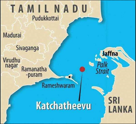
About Katchatheevu Islands
- Colonial Legacy:Originating from a volcanic eruption in the 14th century, Katchatheevu spans 285 acres and was historically administered by the Jaffna kingdom in Sri Lanka and later by the Ramnad Zamindari in India.
- Territorial Claims:In the early 20th century, both India and Sri Lanka asserted ownership over Katchatheevu to delineate fishing boundaries, sparking a dispute that persisted through the British colonial period.
- Pivotal Agreement:Under the leadership of Prime Minister Indira Gandhi, India ceded Katchatheevu to Sri Lanka as part of the 1974 maritime agreement, aimed at defining maritime borders between the two nations.
- Political Fallout: The decision evoked concerns in Tamil Nadu, where protests ensued over the perceived lack of consultation with the state assembly and the potential impact on traditional fishing rights.
Access Provisions: While the agreement granted Indian fishermen access to Katchatheevu “hitherto,” the delineation of fishing rights remained unclear, leading to ongoing disputes and ambiguity surrounding fishing activities in the region.