Liptako-Gourma Charter |
Why in News: Military authorities from Mali, Burkina Faso, and Niger have ratified an important mutual defense agreement named the Liptako-Gourma Charter, signifying a vital advancement in tackling the security issues afflicting the Sahel area.

About Liptako-Gourma Charter
- Alliance Establishment:The Liptako-Gourma Charter initiates the formation of the Alliance of Sahel States (AES), intending to establish a structured platform for collective defense and reciprocal aid among these nations.
- Area Affected:The Liptako-Gourma region, situated at the convergence of Mali, Burkina Faso, and Niger’s borders, has witnessed significant jihadist activities and instability in recent times.
- Unified Efforts:The AES endeavors to merge military and economic endeavors to tackle shared security challenges and enhance the socio-economic conditions of their populace.
Azerbaijan launches crackdown against Armenia |
Why in News: For the second consecutive day, Azerbaijan declared the continuation of military operations in Nagorno-Karabakh, characterizing them as “anti-terrorism” endeavors.
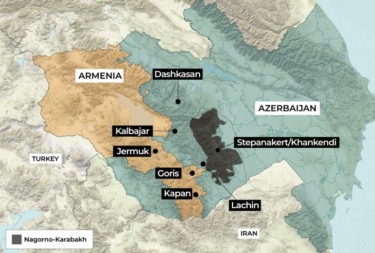
About Azerbaijan-Armenia Conflict
- Ongoing Strife:The South Caucasus area has endured enduring strains revolving around the contested territory of Nagorno-Karabakh, acknowledged internationally as belonging to Azerbaijan.
- Lachin Corridor Restriction:In the previous nine months, Azerbaijan has enforced a blockade on the Lachin Corridor, the sole passage from Armenia to Nagorno-Karabakh.
Gurez Valley |
Why in News: The high-altitude passes in northern Kashmir’s Gurez valley are now connected to the Mushkoh valley in Drass Sector, Kargil, Ladakh, significant during the 1999 war. A newly inaugurated 130-kilometer road, open to tourists, includes Kaobal Gali, a pivotal pass at 4,166.9 meters elevation, bridging these valleys.
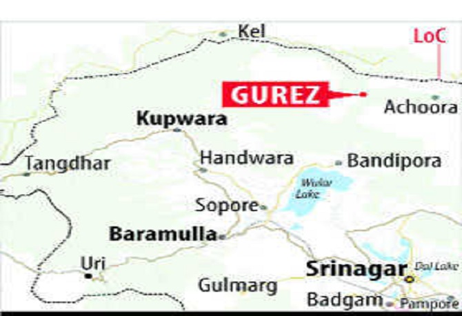
About Gurez Valley
- Kashmir Valley Setting: Gurez is nestled within the Kashmir valley, situated adjacent to the Line of Control, separating it from Pakistan-administered Kashmir’s Astore and Neelum districts.
- Diverse Community: The local populace primarily comprises ethnic Dards/Shins, conversing in the Shina language and sharing cultural affinities with their counterparts in Pakistani-administered Gilgit-Baltistan.
- Buduaab Village and Zumba Yak:Buduaab village within Gurez valley is renowned for its Zumba yak breed, smaller compared to other varieties.
- Role in Kargil War:Gurez valley played a pivotal role during the Kargil conflict.
- Border Locale:Situated close to the Line of Control (LoC), the Kishanganga river delineates the border across multiple areas.
- Log House Villages:Gurez valley is distinguished by its villages entirely constructed of log houses, showcasing traditional architectural styles devoid of modern urban materials.
- Diverse Wildlife:The region boasts a varied array of fauna, including the Himalayan brown bear, snow leopard, ibex, musk deer, and marmots.
Kanwar Lake |
Why in News: Kawar Lake, the sole Ramsar Site in Bihar, is undergoing notable water level reduction and degradation.
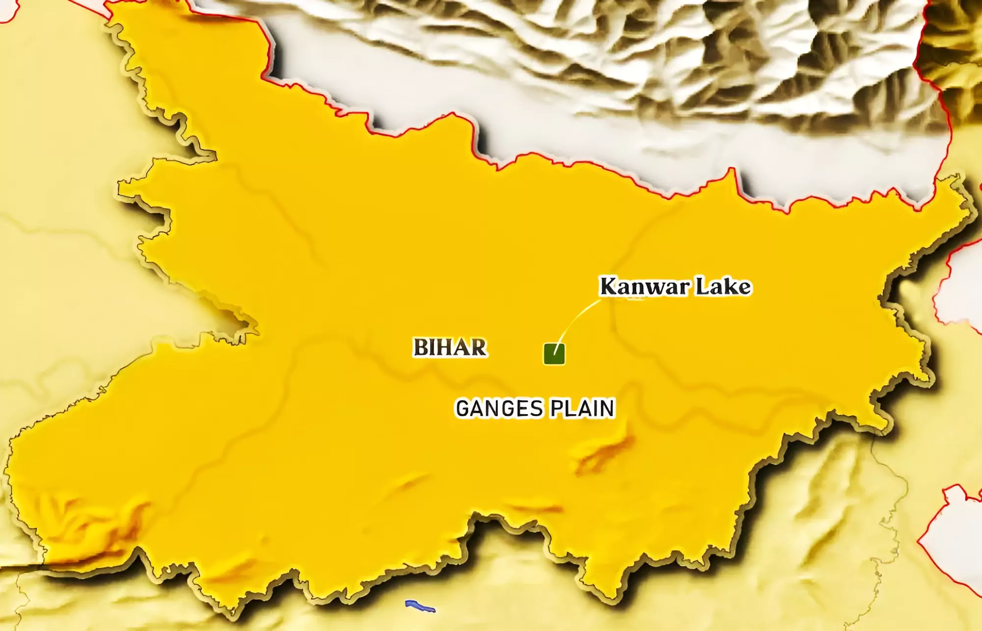
About Kanwar Lake
- Asia’s Largest Oxbow Lake:Kanwar Lake stands as Asia’s largest oxbow lake, nestled in Bihar’s Begusarai district.
- Residual Oxbow Formation:Its creation traces back to the meandering course of the Gandak River, a tributary of the Ganga.
- 2020 Ramsar Declaration:In 2020, it earned the distinction of becoming Bihar’s inaugural Ramsar site, marking its inclusion in the Ramsar convention.
- River Confluence:The lake is fed by the convergence of the Gandak, Bia, and Kareh rivers, nestled near Manjhaul, approximately 22 kilometers northwest of Begusarai, the district’s administrative center.
India-Sri Lanka Ferry Service |
Why in News: Prime Minister Modi launched an international, high-speed passenger ferry service connecting Nagapattinam in Tamil Nadu, India, to Kankesanthurai, near Jaffna in Sri Lanka, across the Palk Strait.

About Palk Strait
- Location:A narrow water body dividing Tamil Nadu, India, and Sri Lanka.
- Origin:Named after Robert Palk, a British Raj-era governor of Madras Presidency (1755-1763).
- Southern Boundaries:Includes Pamban Island (India), Adam’s Bridge (shoals), Gulf of Mannar, and Mannar Island (Sri Lanka).
- Connection:Links the Bay of Bengal in the northeast with the Gulf of Mannar in the southwest.
- Alternative Designation: The southwestern segment of the strait is referred to as Palk Bay.
- Size:Width ranges from 40 to 85 miles (64 to 137 km), length is approximately 85 miles, and depth is less than 330 feet (100 meters).
- River Contributions: The Vaigai River in Tamil Nadu contributes to the flow into the Palk Strait.