Long Period Average (LPA) of Rainfall
Why in News: India is forecasted to experience a monsoon season characterized by rainfall levels surpassing the long-term average, with the India Meteorological Department (IMD) projecting it to be at 106% of the usual precipitation.
About Long Period Average (LPA) of Rainfall:
- LPA represents the average rainfall measured over a specific area for a defined duration, typically spanning several decades such as 30 or 50 years.
- This metric serves as a reference point for predicting the expected amount of rainfall in a particular region for a given month or season.
- The India Meteorological Department (IMD), responsible for monitoring rainfall across the nation, establishes this rainfall norm using data accumulated over 50 years. It undergoes periodic updates approximately every decade by integrating the latest information from rain gauge stations.
- Presently, the LPA for the entire country’s southwest monsoon rainfall, based on data from 1971 to 2020, stands at 868 cm.
- Historically, IMD has computed LPAs at 88 cm for the period 1961-2010 and at 89 cm for 1951-2000.
- Nationally, the annual LPA has experienced a marginal decrease from 117 cm to 116 cm.
Source: HT
Sudan
Why in News: UN Secretary-General Antonio Guterres recently stated that the indiscriminate assaults on civilians in Sudan may amount to “war crimes and crimes against humanity.”
About Sudan:
Geographical Location and Size:
- Situated in northeastern Africa, Sudan is the third largest country on the continent, covering an area of 1,886,068 sq. km.
- It shares borders with seven neighboring countries: South Sudan, Ethiopia, Eritrea, Egypt, Libya, Chad, and the Central African Republic.
- Sudan boasts a significant coastline along the Red Sea, providing crucial access to the Indian Ocean and the Mediterranean Sea via the Suez Canal.
Geography:
- Sudan’s terrain is primarily characterized by vast plains and plateaus, drained by the Nile River and its tributaries.
- Much of the country comprises deserts and arid grasslands with minimal vegetation, particularly in the northern region known as the Nubian Desert.
Historical Independence:
- Following early 19th-century Egyptian occupation, Sudan was established as an Anglo-Egyptian Sudan under British control.
- Independence from Anglo-Egyptian co-rule was achieved in 1956.
- Since gaining independence, Sudan has been dominated by military regimes favoring Islamic-oriented governance.
Capital and Cultural Identity:
- The capital city of Sudan is Khartoum.
- The population predominantly follows Islam and often identifies as “Arabs.”
Languages:
Arabic and English are the primary languages spoken in Sudan.
Source: TH
Lake Kariba
Why in News: The water levels at Lake Kariba in Zimbabwe have experienced a significant decrease due to the recent drought induced by El Niño.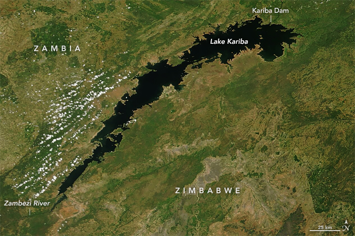
About Lake Kariba:
Size and Location:
- Lake Kariba is renowned as the world’s largest man-made lake and reservoir in terms of volume.
- Positioned approximately 1300 kilometers upstream from the Indian Ocean, it straddles the border between Zambia and Zimbabwe.
- Situated 200 kilometers downstream of the iconic Victoria Falls, Lake Kariba occupies a significant position along the Zambezi River.
Formation and Structure:
- The lake was formed upon the completion of the Kariba Dam wall, which spans the northeastern end of the lake, flooding the Kariba Gorge.
- The Kariba Dam features a double-arch structure, standing at 128 meters tall, 617 meters long, 13 meters wide at the top, and 24 meters wide at the base.
- This dam wall serves as a border crossing point between Zambia and Zimbabwe.
Construction and Purpose:
- Construction of the dam wall commenced on November 6, 1956, and concluded in 1959, spanning a duration of approximately three years.
- Lake Kariba serves as a vital source of hydroelectric power generation for both Zambia and Zimbabwe, while also sustaining a thriving commercial fishing industry.
Size and Area:
- Roughly estimated to stretch about 280 kilometers in length and 40 kilometers at its widest point, Lake Kariba covers an expansive area of nearly 6,000 square kilometers.
Source: DTE